
Martin Silman
We met at the United Reform Church one dark, wet evening last October and had a surprisingly good turnout considering the conditions and the challenge of parking in that area at that time of night - we hope our next meeting on the 19th March will be as well attended.
Our secretary, Patrick O'Hara took the following comprehensive notes of each of the speakers presentations:
The City Local Plan and the Neighbourhood Plan
Lucy Howard, Head of Planning Policy at Portsmouth City Council, discussed the emerging City Plan. The plan has recently been consulted on to ensure it is legally compliant and ‘sound’ (Reg19). Once this process is completed, it will be submitted to the Inspectorate. The current timetable aims for the plan to meet existing housing targets rather than potential future targets. Additionally, there is a request to the Secretary of State to set aside ecological protections at Tipner West as Portsmouth City Council considers there to be an overriding public interest to develop the site. The new development plan will guide city planning until 2042.
The recently adopted Local Neighbourhood Plan, created by the Forum, is now incorporated into the City Plan, making the Milton Neighbourhood Forum a statutory consultee. The Forum’s Neighbourhood Plan is unique in the city and provides more detailed guidance for the area, such as designating Local Green Spaces. Lucy highlighted the importance of maintaining good working relations with the Forum to benefit both Milton and the rest of the city. A statement of Common Ground has recently been agreed upon regarding changes to the coastal zone’s extents and the 'land swap’ proposed for Langstone campus. In the future, the Plan will refer to St. James Green instead of the 'dog park.'
Questions from the audience expressed concerns about building more houses in an already crowded city. Lucy explained that these targets are determined by national policies rather than local authorities.
Portsmouth North Coastal Scheme
We were pleased to welcome Amy Conway from Coastal Partners back to the Forum to discuss the North Portsea Coastal Scheme. Funding has been secured from the Environment Agency, and Knights Brown, who successfully constructed the first and third phases, will build 1.3 km of flood defences. These defences will consist of a sloped earth embankment with a rock armour toe towards the creek, connecting the completed defences at Anchorage Park in the east with Tipner Lake in the west. Initial clearing and excavation works have commenced in this area, renowned for its green open spaces.
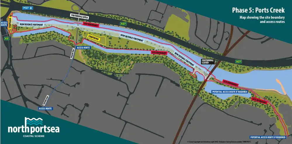 The project is being conducted in collaboration with an on-site archaeologist, given that the area is adjacent to the Hilsea Lines built in the 18th and 19th they are key part of Portsmouth’s historic defences. Designated as a Scheduled Ancient Monument they are the best-preserved example of a bastioned and casemated defensive line in England,
The shoreline is recognised for its unique habitat and carries several important environmental designations. To support and safeguard local wildlife, a variety of nest boxes suitable for breeding birds were installed in advance. Additionally, new bat boxes will be placed in woodland areas to enhance roosting potential, and tunnels will be created for kingfishers to provide additional nesting sites.
The project's emphasis is on revitalising the area known for its green open spaces while preserving its natural feel by planting trees, native shrubs, and wildflowers, and enhancing paths and coastal access. The area will also benefit from new picnic benches, seating, play areas, and viewing platforms.
During the construction phase, Foxes Forest will remain accessible.
Portsmouth South Coastal Scheme
Our second speaker on the coastal defences project was Rena Wiethaupt, Senior Communications Officer at PCC, who discussed the upcoming work on the landward part of Frontage 3 (Southsea Common), from Blue Reef Aquarium to the Hovertravel terminal. The work will require closing Clarence Parade and the promenade until completion in summer 2026. A temporary footpath is being constructed across the Common to provide pedestrian access during construction.
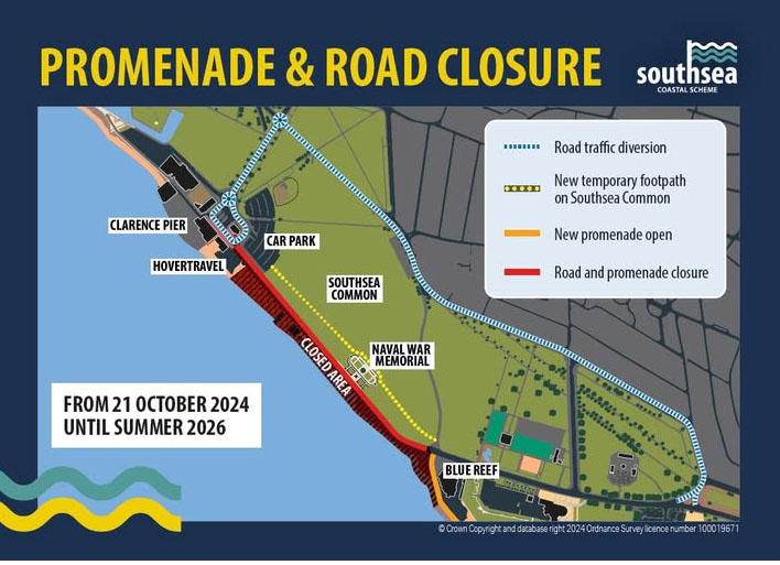
The main sea defence will consist of a combination of stepped and rock revetment, with a managed beach. A raised embankment with a dip slope into Southsea Common will serve as the secondary defence line. The promenade and road will be elevated to maintain sea views and provide level access to the Naval War Memorial. The required height of the defences will be segmented into stepped levels, featuring coastal planted terraces, play areas, and seating.
In addition to essential protection, the sea defences aim to enhance the seafront experience. There will be a one-way road system (westbound) with a single carriageway and a reduced speed limit of 20mph. A 3m wide two-way cycle lane running alongside the promenade will be separated from car parking by a 2m buffer strip. An 8m wide promenade will offer space for events, socializing, and relaxation.
The Grade II listed memorials will be placed centrally along the promenade to create a 'memorial walk.' Coastal planted terraces, play areas, new lighting, and seating will also be included.
It was uncharitably noted that recent storms had caused the new path to become a waterlogged ditch.
Langstone Harbour
Our final speaker was Billy Johnson, the Harbour Master for Langstone Harbour, who gave us a taste of the work he and his team carry out. The harbour covers 4,695 acres at high tide and 495 acres at low tide. It is designated as a Competent Harbour Authority with statutory pilotage duties and acts as a planning consultee for developments within its boundaries.
The marine aggregates industry supplies 17% of the UK's sand and gravel needs, and the harbour brings in 500,000 tonnes of aggregate yearly. Each vessel requires piloting through the harbour’s shallow waters to Kendall’s and Bedhampton wharfs. All sailings are made on the falling tide.
There are various other users of the harbour, including around 1,000 sailing vessels, 470 moorings, board sport enthusiasts, and restricted Jet ski access. The Hayling Ferry transports 45,000 passengers annually. The harbour also hosts a small fleet of commercial fishing vessels.
As a Category 2 response organization, the harbour assists emergency services, manages oil spill responses, and maintains channels marked by buoys. Other operations include maintaining 90 moorings, 43 navigation aids, handling emergencies, search and rescue (SAR), pollution response, and enforcing safety through byelaws and patrols.
The Harbour Board is dedicated to protecting and enhancing the internationally significant habitats and species within its jurisdiction. The environmental designations of Langstone Harbour impose critical obligations on the Harbour Authority to manage the harbour environment in compliance with the Habitats Regulations and the Birds Directive. This includes regulating harbour activities to minimize disturbance and conducting monitoring to ensure compliance.
Langstone Harbour offers diverse habitats, including intertidal mudflats, seagrass meadows, and Atlantic saltmarsh. These habitats provide feeding grounds and shelter for wildfowl and wading birds, optimal conditions for a bass nursery, and a haul-out site for a colony of harbour seals.
Billy concluded by discussing some of the projects the board is involved in with Meg Roberts, the environmental officer. These projects include the Solent Seagrass Restoration Project, focusing on maintaining healthy seagrass beds crucial for productive fish stocks in the region, and a Native Oyster Restoration project.
Thank you to all our wonderful speakers for giving up their time to speak to us.
Patrick O'Hara
Secretary
Milton Neighbourhood Forum